Iceland and Greenland — finding desolate beauty
by Ed Kinney, Contributing Editor
On return flights from Europe, my wife, Moreen, and I often looked down from the sky in awe at the subtle montages of Iceland and the massive ice fields of Greenland, both islands surrounded by the blue Atlantic. We would ask ourselves why we hadn’t visited either place, especially since they are relatively close.
Early in 2006, we began searching the Internet and perused ads and comments in ITN about both islands before we selected Iceland Saga Travel’s 12-day “Magic of Iceland Tour” with a 3-day extension to eastern Greenland for August ’06.
Heading out
Icelandair’s nonstop flight from San Francisco to Reykjavík leaves at 11:35 p.m. four days a week during the late spring and summer months. This late-night flight offers travelers seven-plus hours of rest before arriving in Reykjavík at 3 p.m.
After quickly clearing Iceland’s Immigration and security, we visited the airport’s duty-free shop, available to both outgoing and incoming travelers. Film, liquor, etc., are considerably less expensive here than in local stores.
A waiting Flybus drove us from Keflavík Airport to Reykjavík’s bus depot, where we were quickly transferred to a small van and driven (at no extra charge) to our prearranged hotel, Guesthouse Sunna (www.sunna.is).
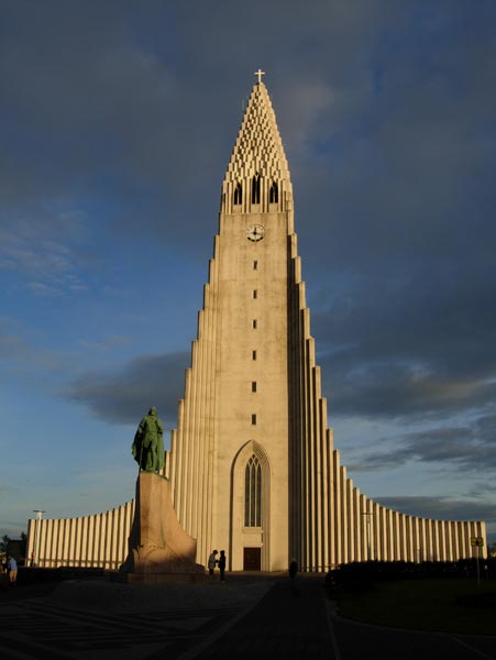
This guest house is located very close to Hallgrímskirkja, the huge, modernistic Lutheran church that towers over the city. Typical of 3-star Icelandic hotels, our room was clean, with two beds and a shower. Free Internet access was available in the lobby.
The following morning Pétur Gauti, our travel guide and driver, met us at our hotel. There would be nine passengers traveling in a 12-passenger Mercedes van. The extra space was great, making it easy to get to needed jackets, photo gear, etc., at stops.
Iceland Saga Travel (Nantucket, MA; phone 866/423-7242, www. icelandsagatravel.com) schedules this unique tour once a year and limits its group size to 12. It would be near impossible to visit some of the areas in the north, especially the northwestern regions of Iceland, in a bus for 30-plus passengers. In many such areas, dirt roads are scraped with a bulldozer, perhaps yearly.
This tour provides adventuresome travelers an opportunity to view seldom-visited areas of Iceland — vast environs of uniquely desolate yet beautiful landscape.
In 2007 the cost for the tour, including airfare from the East Coast, is $5,460 per person, double. Early booking is recommended; at press time, the 2007 tour was marked as “sold out.”
Similar to most tours of Iceland, ours began by following the Ring Road that circles the country, an island the size of Ohio. Among our first stops were the volcanic crater Kerið and a geothermally heated greenhouse. During our tour we visited several greenhouses and now understand how Iceland can serve fresh vegetables and decorate restaurant tables with cut flowers, despite unfavorable outdoor temperatures.
Farther east on Iceland’s Ring Road, our tour visited Geysir with its spouting hot spring. Tourists were lined up to see it and nearby Strokkur (The Churn), which spouts about every 10 minutes. As it’s often very windy at Geysir and because it’s located near Gullfoss, Iceland‘s most famous waterfall, it can be difficult keeping cameras dry due to their spray. A plastic shower cap helped keep mine dry while I composed my shots.
Northern Iceland’s magic
From Gullfoss we turned north, away from the usual tourist route. Shortly, the macadam road, shown on Iceland’s maps as route F-35, became dirt and designated for 4x4 vehicles. We bounced along the next 100 miles only to later realize that this was one of the better dirt roads, especially when compared with many in northwestern Iceland.
Our first overnight stop was for two nights at the charming, deluxe Hótel Tindastóll (www.hoteltindastoll.com), located in the harbor town of Sauðárdkrókur. Tindastóll is the oldest hotel in Iceland, dating back to 1884, though the building itself is actually older. Shipped from Norway, it was assembled in about 1825 as a storehouse before it was moved to its present location.
Like many hotels in Iceland, it has its own hot tub with running natural water at a temperature of about 102°F.
Our dinner that night featured the finest lamb I’ve eaten overseas. Iceland is justifiably proud of its lamb.
Sauðárdkrókur is an ideal base for touring north-central Iceland. Included among several of the local highlights our group enjoyed were a 15-mile drive farther north to view thermal ponds plus an island where, it is said, a true Icelandic must swim naked in the very cold water with a torch in his hand while singing the national anthem.
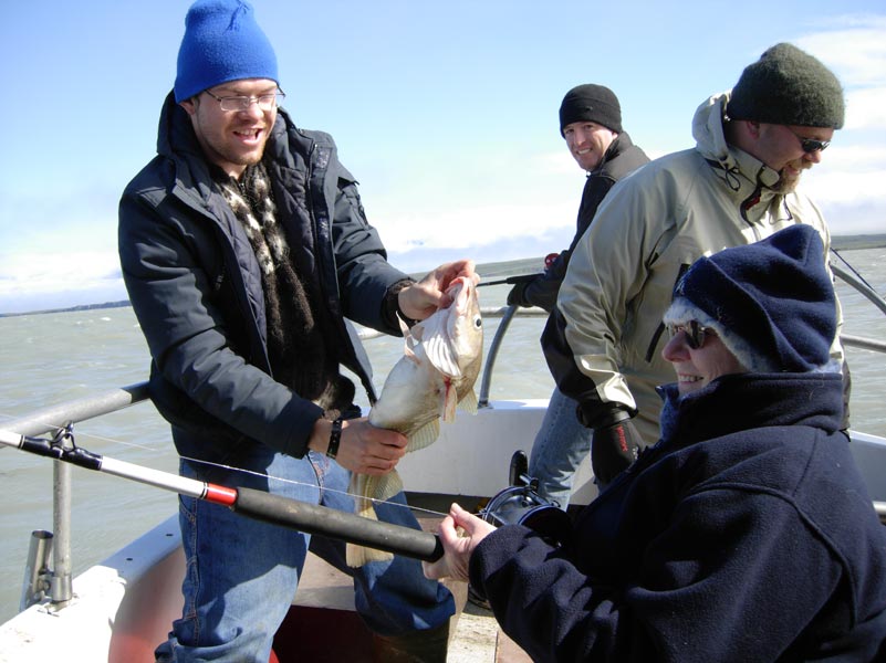
The closest I got to becoming Icelandic was later putting my hand in the water during a wild 2-hour boat ride outside of Sauðárdkrókur’s harbor. Wind-cleared skies tossed our 35-foot boat around while nine brave travelers held on and enjoyed a sparkling view. Later a few of us fished, with two of the women easily catching more than the men!
After a warming soup for lunch, Pétur drove us to Glaumbæ, an 18th-century restored turf farm and museum which features early Icelandic construction. I have to agree with Lonely Planet’s guidebook, this is the best museum of this type in northern Iceland. Museum exhibits include examples of early turf dwellings and later-built timber homes.
Adjacent to the museum, there’s a beautifully built and maintained 1926 Lutheran church with an organ made entirely of pinewood.
Next we visited Flugumri, a horse farm and stable where the husband and wife owners briefed us about Icelandic horses. Three of their children demonstrated equestrian techniques. These Icelandic horses were gentle and certainly enjoyed our attention, maybe as much as we enjoyed stroking their manes.
This wonderful day ended with a delicious seafood dinner at Ólafshús in Sauðárdkrókur.
The many faces of northeastern Iceland
Leaving Sauðárdkrókur under bright blue skies, Pétur drove east a short distance toward the city of Akureyri before turning north onto the Tröllaskagi Peninsula. It was a leisurely ride. Whenever a tour member spotted a picturesque scene, Pétur stopped — an advantage of having a small tour group.
Our first scheduled stop of the day was Hofsós, a tiny trading village dating back to the 1500s. Here we visited the Icelandic Emigration Center, which featured an exhibit tracing the emigration of Icelanders to Canada and the U.S.
Continuing around Tröllaskagi Peninsula, we entered a narrow half-mile, one-lane-wide tunnel at the tip of the peninsula. This is the only entry road to the village of Siglufjörður. Several “wide-outs” permit the passing of cars from the opposite direction.
Siglufjörður was once dubbed the “Atlantic Klondike” due to its gold-rush atmosphere in the early 1900s, but here it was herring that fueled the boom. When the herring disappeared in 1968 due to overfishing, so did much of the town, its population dropping from 10,000 to around 1,000.
Icelanders do a super job highlighting their history; the Herring Era Museum has wonderful exhibits and black-and-white photographs of life as it was in Siglufjörður 100 years ago.
Returning via the same one-way tunnel, we continued paralleling the edges of fjords to Akureyri, the largest city in northern Iceland and only a short distance below the Arctic Circle. Our stay in Akureyri was at the 3-star Hotel Norðurland (www.keahotels.is).
After dinner, we slowly strolled along Akureyri’s one pedestrian-only street, browsing store windows before stopping to enjoy a leisurely cup of coffee outside in the early evening sunlight.
There is a good bookstore on this pedestrian street, but its most recent English-language newspaper was a week old. We found the Internet, with access available in many hotels, to be the best way to stay current throughout Iceland.
Good weather continued as we again followed Iceland’s Ring Road, traveling east a short distance to view Goðafoss, one of the country’s more accessible major waterfalls. Pétur then left the Ring Road and turned north to the colorful fishing village of Húsavík before driving a few miles farther to the tip of the Tjörnes Peninsula. Here puffins were floating quietly in the sea while hundreds of other birds raced to and from nests built into steep hillsides.
Photographers will need a 600mm or 800mm camera lens for good shots here.
I have two recommendations for photography enthusiasts visiting Iceland:
• Due to the capricious Icelandic weather, don’t set a photographic schedule until your arrival.
• Consider using the Iceland Saga Travel guide we had, Pétur Gauti. He is an excellent photographer. You can view samples of his work at http://pgv.smugmug.com or contact him at pgv@simnet.is.
A nearby lighthouse is a good place to view the distant island of Grímsey, which lies within the Arctic Circle. My windbreaker felt good in the sunny but windy 45-degree temperature.
Next on our tour schedule was Jökulsárgljúfur National Park, often described as Iceland’s Grand Canyon, with its horseshoe-shaped Ásbyrgi Canyon. Early Norse settlers, being very superstitious, believed an airborne horse touched down on Earth, leaving its hoofprint.
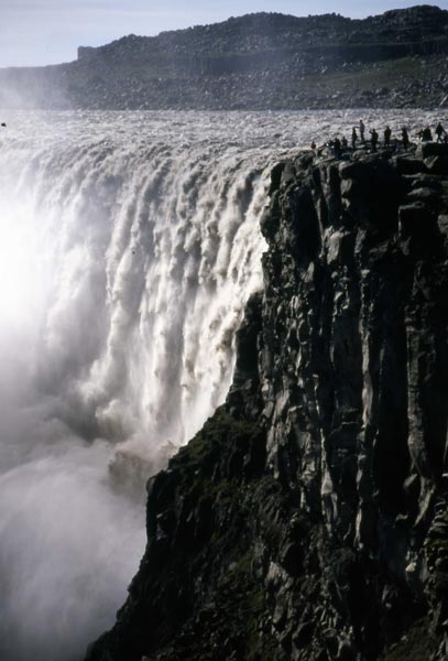
Dettifoss, considered Europe’s greatest waterfall, is located at the southern end of this national park. Iceland is justly proud of this park with its tongue-twisting name.
Having traveled nearly to the northeastern corner of Iceland, we now turned west on the Ring Road toward Lake Mývatn. The road passes the Krafla Caldera, a volcanic wasteland of lava, blowholes and mud pots emitting bubbling liquids with sulfurous gases and surrounded by sterile soil of various colors. Geologists predict Krafla will erupt again in a few years, adding to its mystique.
Too soon, we left for the 3-star rated Hotel Reykjahlid (www. reykjahlid.is) overlooking Lake Mývatn.
The desolate beauty of the west
Continuing our drive on the Ring Road toward northwestern Iceland, Pétur stopped at the small village of Svalbarðseyri on the Eyjafjörður (fjord). Here, Iceland Saga Travel had purchased 35 trees for us to plant later.
The balance of the day was spent driving west to Hotel Borgarviki, located in a very remote farm area miles south of the village of Blönduós.
The weather continued to be excellent but cool as we visited an ancient stone fortress situated on a high ridge several miles from Hunafjörður. Though crude, it would have required a massive effort to construct.
The dirt road then began to twist back and forth, up and down, following the curve of each fjord’s invasion into this part of northwestern Iceland. An occasional small home, a few sheep and maybe a horse were the only variations in the landscape of purplish-colored lava rocks draped high on steep mountains and vast undeveloped green areas sloping down to the fjord waters.
After more than an hour the village of Hólmavík, the largest village in this region, appeared. Each village we visited in northern Iceland had its own surprise. This one featured an exhibition of 17th-century sorcery and witchcraft.
Our lodging for the next two nights, Hótel Laugarhóll (www.strandir.is/laugarholl), was very nice, situated in the Strandir region and far from any village. Many Icelanders and Europeans come here to hike.
Pétur spoiled us the next morning by allowing us an extra hour’s sleep, something I needed as I had gotten up at 1 a.m., put a windbreaker over my PJs and gone outside in hopes of seeing the Northern Lights. I didn’t see them, but I certainly got cold in the near-freezing temperatures.
Our drive this day was into one of the most beautiful yet remote areas we’d ever seen in a developed country. It took eight hours to drive the 100-mile round trip to Minardarnes.
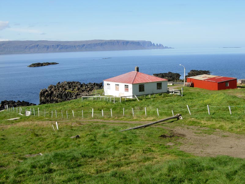
There were three family homes at the very end of this, the roughest stretch of road that we experienced in Iceland. Yet we were fascinated by the beautiful, desolate landscape broken only by a rare single red house among green fields and by a sign beside the road classifying the two adjacent houses as a village. A single vehicle passed us during our day’s drive.
The only people we encountered were in two villages, one an abandoned fishery and the second an even smaller village which had an “open” museum highlighting sorcery, with a list of those burned at the stake for witchcraft. Neither village is listed on Iceland tourist maps. Only the names of two fjords, Reykjafjörður and Norðurfjörður, are listed in this area, called “the most remote and rugged place in Iceland.”
Driving to Reykjavík
The weather turned overcast as we drove over a 3,000-foot-high mountain ridge toward the fjords of western Iceland. Soon Pétur found “the” spot to plant the earlier-purchased trees. Ten of us, each using a sharp stick, easily dug holes in the spongy soil for the 35 small evergreens. The effort may have been small, but the gesture was sincere. Iceland is basically naked of trees, cut earlier for firewood and construction.
Continuing around the Klofningur Peninsula, we encountered worsening weather, though passing scenes would have justified many photographic stops if it were sunny. Soon it was time to drive to that night’s lodging, the 3-star Hótel Edda Laugar (www.hoteledda.is), part of the Hotel Edda chain.
We continued around the Snæfellsnes Peninsula, our stops brief due to the inclement weather, and spent the night at the very nice Fosshótel Reykholt (www.reykholt.is).
On the last day of our Iceland tour, Pétur drove us to the very edge of Langjökull Glacier. We’d viewed its opposite side while driving north from Reykjavík on our first tour day.
The weather was as bad as the road, but, having come this far, we walked the last 100 yards in freezing, windy conditions to stand on the glacier’s edge. The adventure was there, but photography was near impossible.
Following the perimeter of Skarðsheiði Peninsula, we viewed Glymur, at 643 feet Iceland’s highest falls, then visited Þhingvellir National Park. Inscribed as a UNESCO World Heritage Site in 2004, it is the only such site in Iceland.
Too soon we were back in Reykjavík after having driven through some of the most wildly beautiful, desolate and diverse landscape I’d ever seen. Yet it’s the people that make a country, and Icelanders are wonderful hosts.
On to Greenland
• Pack a warm jacket and head covering, as temperatures, even in midsummer, may drop into the 30s. Gloves are recommended for long hikes and boat rides.
• Take lots of film for your camera and/or a digital camera with ample memory and a battery charger. Carry a 2-prong European electrical adaptor, as Greenland has 220 voltage.
• Flights to eastern Greenland originate either in western Greenland or Iceland. Air Greenland plans to begin flights to western Greenland from Baltimore, Maryland, beginning in May 2007.
During our travels, Moreen and I have several times skipped side trips only to later discover we’d missed a great adventure. Shortly after scheduling our trip to Iceland, Iceland Saga Travel sent us information regarding a possible extension to eastern Greenland. The extension sounded interesting, especially since it would be only a 2-hour flight from Iceland’s Reykjavík City Airport.
It was misty and overcast the morning we left Reykjavík for Greenland. We crossed our fingers and the travel gods smiled. When we landed at eastern Greenland’s main airport in Kulusuk, a village of perhaps 300 inhabitants, the skies were crystal clear except for a few puffy white clouds occasionally hiding the surrounding snow-covered mountain peaks.
Most of the 70 passengers on our twin-prop Icelandair flight stayed in Kulusuk, but we flew on to Ammassalik (also called Tasiiliq). This required a 15-minute helicopter flight over the mountains surrounding Kulusuk and the icebergs floating in the calm blue seas below. The helicopter flight provided us a fantastic approach to Ammassalik.
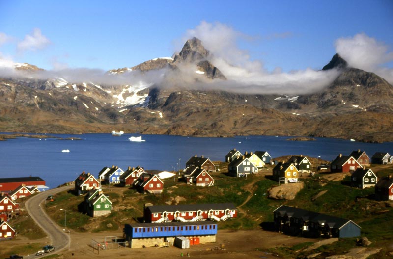
We were met by a representative of Arctic Wonderland Tours, the operator of both Kulusuk and Ammassalik‘s international hotels, and were driven a mile to Hotel Angmagssalik, our home for the next two nights. It is a relatively modern hotel built high on a hillside overlooking the village of Ammassalik.
Brightly painted homes, the village’s harbor docks and fjord waters with large chunks of randomly floating ice became the stage to our balcony seats.
Ammassalik
Ammassalik is the largest village in eastern Greenland. Of Greenland’s more than 56,000 inhabitants, only 3,000 live in the entire eastern half of Greenland, with 1,600 living in Ammassalik. Inhabitants of eastern Greenland are mostly Inuits, with a smattering of Danes and other Europeans. A majority of these support themselves by hunting (seals and whales) and fishing, with generous assistance from the Danish government.
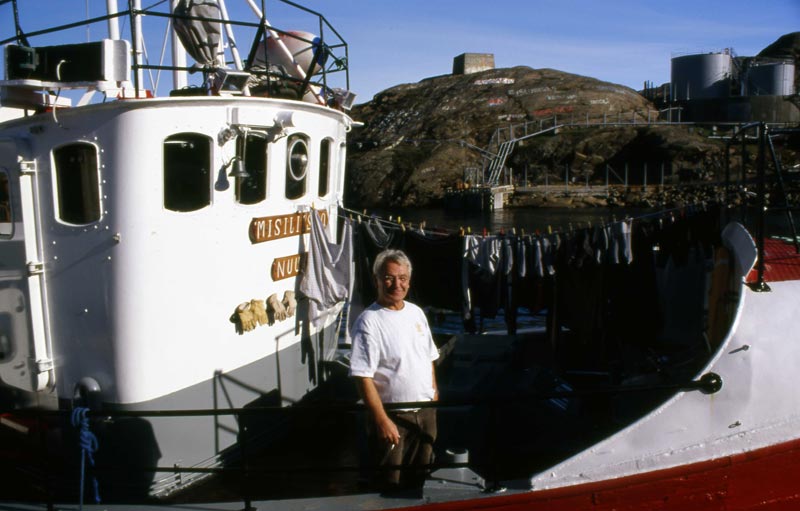
Seven shiploads of supplies and two tankers with petroleum products arrive yearly during the short summer season, usually July through early October, when ships plying this fjord are not endangered by icebergs. Life in eastern Greenland is desolate and rough.
Locals we met during our many hikes throughout the village treated us with a quiet look or a shy smile and a slight nod of the head. We never witnessed begging or experienced adverse comments.
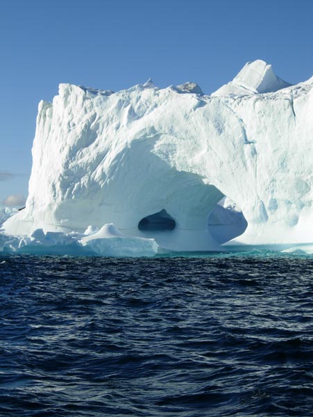
The highlight of our visit was a late-afternoon cruise from Ammassalik harbor in ideal photography weather. The skipper of our 40-foot diesel fishing boat slowly circled several small, cruise-ship-sized icebergs of varying shapes in the pristine frigid waters for two hours. The icebergs were beautiful in the late-afternoon sun.
We also were very impressed with the area’s exceptionally clean environment, in town, in the local harbor and in its fjord waters.
In addition to this boat trip, we enjoyed taking long walks throughout Ammassalik, studying its buildings, examining artifacts in the Ammassalik museum, looking at wildflowers in the nearby hillsides and, of course, observing its people.
Lastly, and probably most important, we enjoyed the fantastic view of Ammassalik from our bedroom window and the hotel dining room.
I’d rate our hotel, with its 30 moderately furnished bedrooms with private bathrooms and showers, about three stars (10 other bedrooms have wash basins).
All meals were included in our standard tour package. Food was served buffet style, though specials were available. The food, which included lamb, beef, fish and vegetables, was surprisingly good. Everything was imported and stored before preparation except locally caught fish.
Booking details
In 2007, Iceland Saga Travel offers a complete 3-day package which includes flights to and from Iceland, meals and private facilities in either Kulusuk or Ammassalik, for $1,548 per person. The helicopter flight to and from Kulusuk is included in this package price. Two- and 4-day packages are also available that include stays in either of the villages or a combination of both.
The staff at our hotel spoke Inuit, Danish, English and, likely, other languages. The local currency is the Danish krone, though we never exchanged either our dollars or Icelandic krónurs, instead using a credit card for hotel purchases and tours.
Arctic Wonderland Tours (East Greenland; phone +299 98 1493, www.arcticwonder.com) can arrange boat cruises, helicopter tours, mountain hikes, etc., during the summer season (June 15-Sept. 10) and dogsled and other such excursions during the spring (March 1-May 15). All tours are arranged after arrival in Greenland.
Greenland has much to offer visitors. It’s certainly safe, is relatively close to the U.S., and it will provide travelers with, hopefully, wonderful memories.
Editor’s note: Ed and Moreen Kinney received an almost-25% discount on their tour and business-class airfares, provided by Iceland Saga Travel.