Cape Verde Islands
This item appears on page 86 of the May 2008 issue.
(Third of three parts on The Gambia and the Cape Verde Islands, jump to part 1, part 2, part 3)
Volcanoes, salt and slavery
When I opened the Bradt Travel Guide “Cape Verde Islands” (Globe Pequot Press; www.bradtguides. com), which I bought for an October ’07 trip, I was fascinated with one of the opening comments: “When we commissioned the first edition of this guide in 1997 it seemed an almost impossibly obscure destination.”
Even though 10 years had gone by since that comment was made, and although tourism there had probably grown, I expected that a trip to this rarely visited volcanic archipelago — off the coast of West Africa, some 600 miles south of the Canary Islands and scattered from 275 to 480 miles off the coast of Senegal — would be a fine source of “soft adventure.”
Plate tectonics
The 10 principal islands of the Cape Verde Islands were formed as a result of plate tectonics.
Segments of the Earth’s crust apparently “float” over a molten core. Some of these enormous “plates” constantly grind past one another in a “stop and go” manner, creating earthquake zones such as California’s San Andreas Fault.
When these plates collide, one edge of a crust is forced under another, forming not only earthquake zones but wrinkling the Earth’s crust, raising mountain ranges. This explains why fossils of sea creatures are found today in South America’s Andes Mountains. Additionally, sometimes “hot spots” are formed where molten magma rises to the surface. (Think Kilauea Volcano in Hawaii.)
As eons pass, the Earth’s plates “float” along over these “hot spots,” creating chains of volcanic islands. This is what formed the Hawaiian Islands in the Pacific Ocean and the Macronesian islands in the Atlantic of which the Azores, Canaries and Cape Verde Islands are a part.
The time scale of these island-forming forces is mind-numbing. Cape Verde’s Fogo Island, the youngest, at 100,000 years old, still has an active volcano. It last erupted in 1995. The islands of Sal, Boa Vista and Maio are flat. They have been around long enough, some 26 million years, to have had most of the signs of their volcanic origins eroded away.
The reason I’m inserting this geography lesson at the beginning of my trip report is that the geologists who were formulating the theory of plate tectonics were scorned by most scientists until the late 1960s when research using radioisotope dating resulted in a new field of geologic study.
If you received most of your formal education prior to those days (as I did), then you missed learning about the, now, generally accepted theory that changed the earth sciences and finally explained not only the forces that generate earthquakes and volcanoes but why these occur where they occur.
It’s not too late to get up to speed on geology lessons that you may have missed. You really do have to keep up with your grandchildren so they don’t continue to ask, “Grandma, were there dinosaurs when you were young?”
If you have computer access, punch up “plate tectonics” for a Wikipedia display and explanation. Also, I highly recommend the book (but, better, the book on tape produced by Harper Audio) “Krakatoa” by Simon Winchester.
But back to my trip report! Volcanoes, salt and slavery are part of the Cape Verde Islands’ history specifically because of their origin and location. These three factors were responsible for some of the memorable highlights of my soft-adventure experience.
Spectacular, volcano-produced scenery
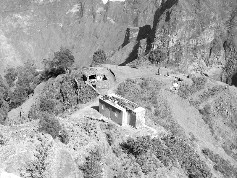
Imagine a thin book opened slightly and standing on edge with the spine up. Imagine driving on a road along the spine of a mountain (the Ribeira Grande) that looks like that book, with views on both sides down into 3,000-foot-deep valleys and with a continuing series of dramatic, rugged mountain ranges as far as the eye can see.
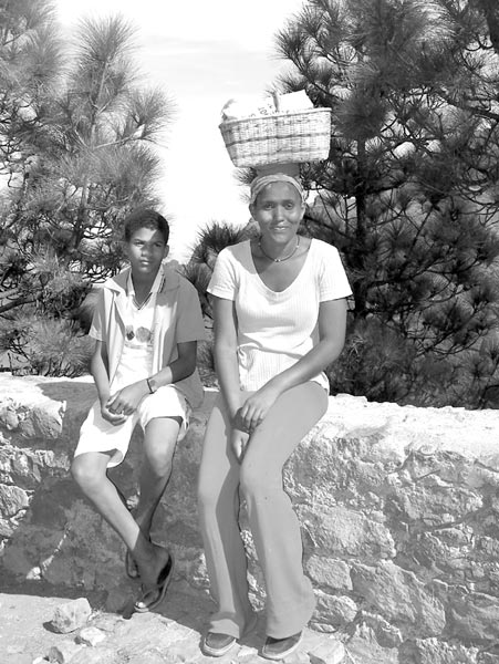
On the island of Santo Antão, farming villages at the bottoms of these canyons seem to be cut off from the outside world by the colossal volcanic walls.
Viewing this unfolding scenic panorama is a one-of-a-kind experience. The drive is not one to generate fear of heights, as some do that I’ve been on in Colorado’s Rocky Mountains. Very sturdy stone barriers line both sides of the wide roadway, and the curves generally are gradual.
Slave-built roads
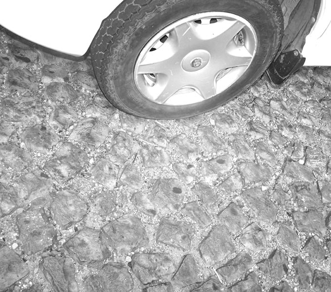
In the Cape Verde Islands, roads, even sidewalks and public squares, are made of small, irregular stone cubes, probably set in sand. The volcanic stone readily fractures into this size and shape.
The white lines down the center of the roads are not painted; they are hand-set cubes of a white stone also found there. We frequently saw individual men along the roadside breaking large stones into these small cubes.
We were told that these cubes are sold to the government to be used for road repair and are a source of income for ambitious and strong young men.
Slave labor was originally used to produce this durable but labor-intensive paving system, still in use in the hundreds of miles of roads throughout the islands. The roads that I saw were all in good repair, but the cobblestone-like surface generated a constant minor rumbling in the tires of vehicles.
Salt
On the island of Sal (Latin for “salt”), there is a no-longer-used source of salt that was a very valuable commodity as far back as 400 years ago. Today Sal is a popular destination for seaside watersports and for the reported health benefits of immersion in very salty brine.
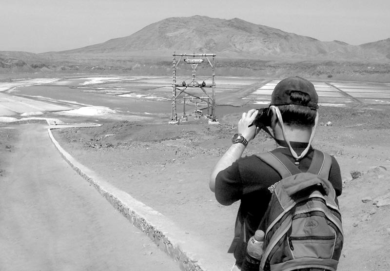
We visited a salt lake at the bottom of an extinct volcano that is one-half mile from the coast and below sea level. This source of salt was mined heavily for centuries, the salt being replaced through the evaporation of nearby seawater that continues to seep into the crater.
As recently as 1985, as much as 25 tons of salt per hour (!) were pulled out on a tramway built through a tunnel carved through the crater sidewall.
We walked through the tunnel for the view of the salt lake and a health spa that is apparently very popular with Europeans. We shared the tunnel on a hot, sunny day with whole families in bathing suits and towels, their cheeks rosy and their faces filled with smiles.
Stone walls divide the lake into “ponds” of varying salt densities, with corresponding colors of blue, pink and green. We were told that a sequence of immersions in increasingly briny ponds was a standard procedure for treatment at this spa.
I can imagine that the slaves who mined the salt in the bad old days would be stunned to see the modern spa buildings and the parade of healthy-looking families now paying to take a series of soaks in colored saltwater.
Mirage on the desert
On the island of Sal there’s a spot where they take all the visitors to observe a mirage. On a flat sandy desert, this spot reveals a mirage very like the ones that appear all the time in cartoons.
In the middle distance I saw what appeared to be a large, shimmering, beautiful blue body of water with a palm tree for emphasis. It was absolutely believable. If I had been alone and lost in this desert, I surely would have headed off in that direction expecting to find cool, clear water. The palm tree was there, in fact, but the water was not.
And, yes, one can photograph a mirage. My photos clearly show the bright blue image, but, because of some haze and the apparent distance involved, they would not reproduce well in black and white.
If you have Internet access, punch up “desert mirage” for an explanation of this dramatic phenomenon.
African slave trade
Cape Verde figured prominently in the African slave trade in the 1600s and 1700s.
These islands presented some advantages for slave traders. They were closer to the Americas than the African mainland, which meant less traveling time. Less travel time meant less loss of slaves due to dreadful conditions in crowded sailing ships.
It’s estimated that some 3,000 slaves a year left the Cape Verdes in the peak years of 1609 and 1610.
The other big advantage for slave traders in these islands was the fact that slaves for sale here were “seasoned.” That is, during their brief stay away from the African continent where they originally had been captured, they had become somewhat used to their situation, were sure to be healthy and had learned a few words of Portuguese so that they could follow orders.
Although the “business” of slavery ended in the Cape Verdes in 1854, slaves already here continued to be only partly free well into the 1900s. The island nation finally declared independence from Portugal in 1975
On our visit to the town of Praia on the island of São Tiago (Santiago), we saw the carefully preserved/restored slave days “business district.” The tiny, dark stone hovels on “Main Street” were the homes of the slave traders. Slave quarters were worse, of course.
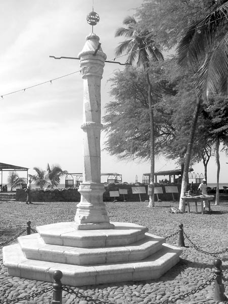
The grimmest sight of all was a 10-foot-tall pelhourinho (pillory) used for the punishment of slaves. On the top of this slender stone obelisk were mounted four radiating horizontal metal bars. Slaves being punished were made to stand in the center of the town square with their arms held over their heads by chains — public displays meant to discourage disobedience.
I’ve seen a similar pillory at the other end of the slave trade in a preserved “old town” slave-selling square in the coastal Brazilian city of Salvador.
A major positive result of these preserved “business districts” is that the dreadful aspects of the slave trade have not been hidden or erased and that future generations can learn from the past.
Cruise information
On this 12-day trip, an MS Bremen cruise on which I was a guest of Hapag-Lloyd Cruises (631 Commack Rd., Ste. 1A, Commack, NY 11725; 877/445-7447 or 631/858-1252, www.hl-cruises.com), we embarked in the Canary Islands, visited four of the Cape Verde Islands and then made our way to Africa’s tiniest country, The Gambia, about which I wrote in my last two columns. We disembarked in Dakar, Senegal. (This cruise is not scheduled for a repeat in 2008.)
Exclusive of international airfare, the cost started at $5,425 per person, double occupancy, for an outside cabin and included full board, mini-bar, all tips on board, lectures by experts, and all landings and tours on the ship’s Zodiacs.