Journey to Samarkand — traveling overland from Pakistan to Uzbekistan
by Tom McKenna, Montpelier, VT
Samarkand. The name evokes images of the ancient Silk Road, Genghis Khan, and camel caravans plodding across Central Asia. It brings to mind the Khyber Pass, scorching deserts and some of the highest mountains in the world.
I reserved my April-May ’06 tour of the area more than a year ahead to be certain I was one of the 16 travelers included on ElderTreks’ “Silk Road Journey to Samarkand.”
The journey begins
The tour started in Islamabad, Pakistan, continuing to western China and through the former Soviet republics of Kyrgyzstan and Uzbekistan. All the land travel was by air-conditioned bus, but there were two flights between Kyrgyzstan and Uzbekistan.
Many Americans are, understandably, cautious about traveling in this part of the world today, but we never felt threatened and virtually all of the people we met were pleasant and welcoming. Pakistan practices a strict form of Islam; most of the women were covered from head to toe and there was no alcohol for sale. Religious practices were much more relaxed in the other three countries.
Our excellent Dutch guide, Leon van Neer, stayed with us through the entire trip, but we had a different national guide in each country and some additional guides in big cities.
In Islamabad, the capital of Pakistan in the Punjab Province, we recovered from jet lag in a wonderful hotel, Islamabad Serena Hotel. However, Leon cautioned us that not all our hotels would be luxury level.
Islamabad is an oasis in the desert. From there we took several day trips, visited markets and adjusted to the group’s dynamics. When we returned to the bus one afternoon, the thermometer on my day pack read 112°F. Of course, someone pointed out, “But it’s dry heat.”
We followed the historic Grand Trunk Road to Peshawar, in the Northwest Frontier Province. Even in the desert, there were many green irrigated farm fields. On the way, we visited the ruins of an ancient planned city where excavations were still in progress. It was cooler in Peshawar — only 98° in the shade.
The Khyber Pass
A special permit is required to enter the Khyber Pass (luckily, our request was approved) and our guide obtained it the morning we left for the pass.We were required to take two guards from the Khyber Rifles, armed with AK-47s, on the bus with us. This was standard procedure.
Just outside the pass, there was a large empty area where hundreds of thousands of refugees from Afghanistan had been camped since 2002. When we arrived it was almost empty because the refugees had been forced to leave. There were about a hundred brightly painted Pakistani trucks piled high with the refugees’ household goods. Lined up side by side in two columns, they were waiting to convoy over the pass to Afghanistan.
At the entrance gate to the Khyber Pass, there was a large sign warning, “NO FOREIGNERS BEYOND THIS POINT,” but we had the coveted permit, so we rolled past it and into the area controlled by tribal leaders and warlords.
We rode through a strip city of low buildings where you could, allegedly, buy anything from heroin to explosives and custom-made weapons. We were not allowed to stop and shop.
The road up the Khyber Pass was steep and winding and the surrounding hills were barren. Many high points had old forts manned by the Pakistani army. No photographs were allowed.
There were a few strip villages along the road and some compounds surrounded by high walls. Several times, through open compound gates, we saw villas with lush lawns, flower gardens and swimming pools.
At the top of the pass we were allowed to walk to the fence and take pictures of the border with Afghanistan far below.
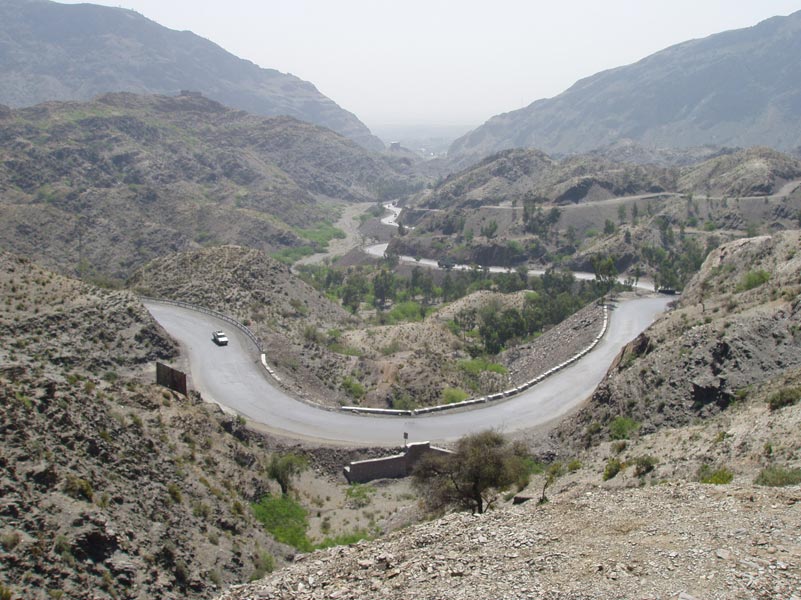
The Karakoram Highway
The Karakoram Highway goes through some of the highest mountains in the world. We would spend six days above 8,000 feet and go over two passes nearly 16,000 feet high. I took pills to prevent high-altitude sickness. Here, it was so cold that I wore my thermal underwear day and night for three days.
I naively assumed that “highway” meant at least a 2-lane asphalt road, but long stretches of it were little more than a gravel jeep trail that switchbacked up and down and around steep mountains. A blowout could send a bus plunging thousands of feet to the valley below.
There were landslides, rock falls and detours through dry, rocky river bottoms. Several times we had to wait while the Pakistani army used a bulldozer to make the road passable.
Our bus was of good quality, but the shock absorbers were probably shot from too many rough roads, so the ride was sometimes bone-jarring and often swinging and swaying. I took Bonine® for motion sickness.
At one place, we left our bus and took jeeps up a rutted trail to see a giant Buddha that was carved high up on the sheer face of a cliff. Most of the Buddha images in Central Asia had been defaced or destroyed many centuries before by the invading Muslims.
At the intersection of the Gilgit and Indus rivers, we stopped to see the only place in the world where three major mountain ranges — the Great Himalayas, the Karakoram and the Hindu Kush — meet.
On three or four days we endured over 13 hours of travel each day, most of that time spent on the bus, but it was worth it because the scenery was spectacular.
Northern Pakistan has four mountain peaks over 26,000 feet high, another 68 peaks over 23,000 feet and hundreds over 19,500 feet high. In some places, the highway followed a broad river valley with little or no water in the river. On other stretches, on both sides of the road a flat, barren area blended into barren foothills and then into high, barren mountains. Beyond them we could see the snowcapped peaks of the highest mountains.
In the Hunza Valley we spent three nights in the city of Gilgit, which my National Geographic map shows is in Kashmir. The main attraction in Gilgit is Baltit Fort, which sits on a small mountain with high, jagged peaks rising behind it. Built in the Tibetan style, it reminded me of the Potala Palace in Lhasa.
Despite never eating street food, passing on the local salads and rubbing sanitizer on my hands and tableware before every meal, I suffered from a mild case of travelers’ diarrhea for most of the trip and usually took an Imodium® at breakfast before long bus rides. I dislike peppery foods and am suspicious of ground meat, even in America. Despite those limitations, I never felt hungry.
Most of our meals were buffets that included at least a couple main courses, good bread, vegetables and fresh fruit (especially apricots). Overall, the food was good, but, then, I like mutton.
Leon kept us well supplied with bottled water, but toilets often were few and far between. Except in the hotels and restaurants, most of the public toilets were disgusting, and the women rejected a few as totally unusable. Sometimes we parked on lonely stretches of highway with low sand dunes on either side and Leon would direct, “Boys to the left, girls to the right.”
On to China
At 15,372 feet, the Khunjerab Pass between Pakistan and China is the world’s highest border crossing. On the other side of the pass, down at the actual border stations, there were hundreds of trucks piled to overflowing with scrap metal and lined up at the border, waiting to deliver their cargo to China’s blast furnaces. Fortunately, tourist buses took precedence over trucks full of junk and we went to the head of the line.
We changed to a Chinese bus with a country guide, and a day later we were in Kashgar, the westernmost city in China. The rice was moist and glutinous, the other food was great, and there was cold beer to wash it all down.
Four branches of the ancient Silk Road converged in Kashgar. There are high mountains on three sides and the Gobi Desert on the fourth.
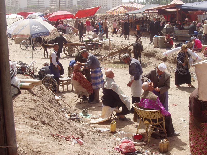
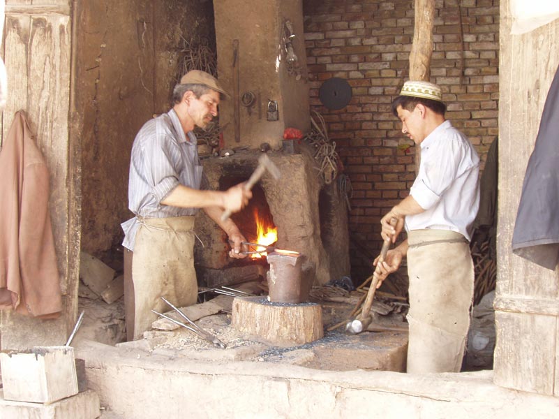
There was an especially interesting street market with workmen hammering copper pots or making jewelry, and the shops sold everything from Uygar hats to raw meat.
A 2,000-year-old section of the city escaped the Communist wrecking ball only because it’s a tourist attraction. We were able to wander through its narrow streets and even visit a home there.
On Sunday morning we went to a livestock market where doves, pigeons, cows, sheep and goats were for sale. At another outdoor market, around a dozen men were sitting outside getting a shave while nearby a snake-oil salesman was surrounded by a crowd four deep. He dipped the liquid off the bowl of dead, skinned snakes, used a funnel to bottle it and sold it as fast as he could accept and stuff dirty paper money into his pocket. He also had a couple of foot-long desert lizards on string leashes, an enormous African frog in a pan of water, and a big bowl of 3-inch live scorpions. Kashgar was one of my favorite places on this tour.
The “stans”
Upon our leaving China, the Chinese officials closely inspected our passports, pick-and-pecked a lot of the data into a laptop, and x-rayed our departing bags. We were then in Kyrgyzstan, where 94% of the country is covered by some of the highest mountains in Central Asia.
It’s officially The Kyrgyz Republic, apparently to distinguish it from the other “stan” nations in the neighborhood, as some of them have bad reputations.
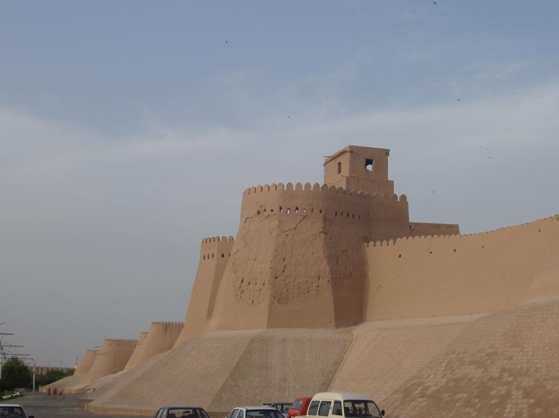
We flew from Bishkek, Kyrgyzstan, to Tashkent, Uzbekistan, and on to Khiva, another city on the ancient Silk Road, in western Uzbekistan. Khiva has ancient mud walls, much like the great Red Fort in India.
Our first afternoon was spent on a walking tour inside the walls of the Old City. We were in another desert and my day pack thermometer read 102°F — but dry heat, of course.
Following a 5:30 a.m. wakeup in Khiva and an 8-hour ride across the desert, we arrived in Bukhara, Uzbekistan. After having changed hotels every night for five nights, we were pleased to spend two nights in Bukhara.
On our first day, we took a walking tour of the city with a nice Coke break at shady tables beside a river. The next day, there was more walking and a visit to the Old City. There were very few veiled women here. Miniskirts and spiked heels were more the fashion.
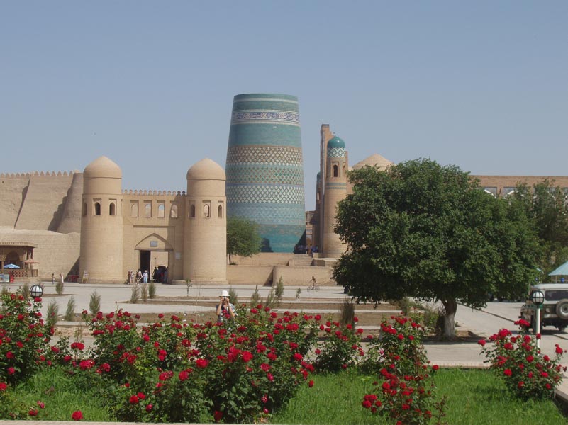
Samarkand
The final leg of our journey was by bus from Bukhara to Samarkand. This is now a city of over 400,000 and there are far more Mercedes than camels on the streets. However, it is still extremely interesting.
We stayed in a hotel across the street from the mausoleum of Timur (Tamerlane, or “Timur the Lame”), who has been described as “a tyrant’s tyrant.” He is the national hero of Uzbekistan. Alexander the Great seized Samarkand in 329 B.C., Genghis Khan sacked it in 1220 and Timur made it his capital in 1370. Timur brought his loot and captured artisans back to Samarkand, turning it into a city famous for its art and architecture.
Notes and recommendations
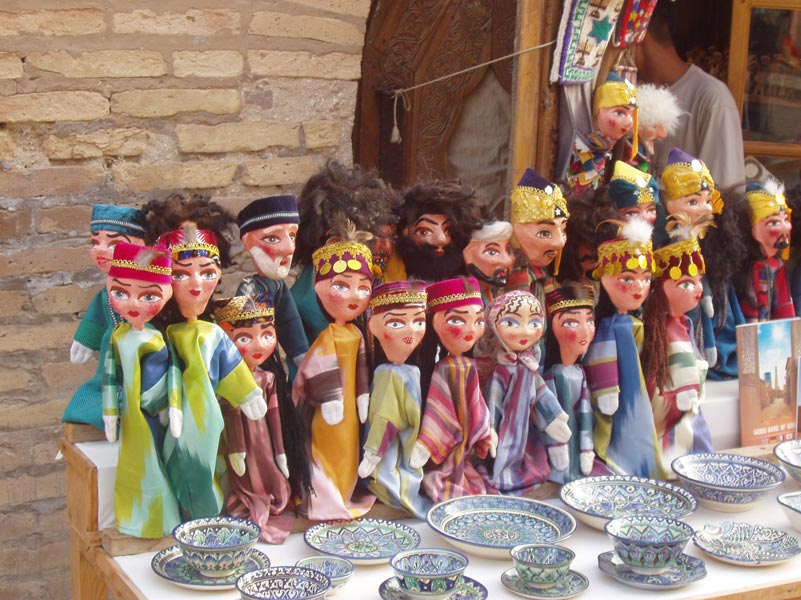
Two days later we departed Samarkand by bus for Tashkent and flew home from there. During the 4-week trip we saw a lot of mosques, mausoleums and madrasas, but my favorite place to visit, wherever I travel, is the street market, and Central Asia’s markets are among the best.
All of the hotels we stayed in were adequate, and some were luxury level. After Pakistan we had buses large enough to allow two seats per person.
Every few days we had access to an Internet connection in our hotel or an Internet café. Almost all were dial-up connections in countries where the basic phone service is nothing to brag about, so receiving and sending e-mail was time consuming and often frustrating. All my e-mails to my wife were rejected by the security settings on our home computer. In one case, the reason was “Sent from Kashgar, China.”
Anyone who likes to visit places way off the beaten tourist path should enjoy Central Asia. Buy your guidebooks and maps before you go. I recommend Lonely Planet’s “Central Asia” and “Pakistan and the Karakoram Highway.” There is a Nelles 1:750,000-scale Central Asia map and a 1:1,000,000-scale map of The Karakoram Highway by John Callanan that also has many insets of the Central Asian cities.
It’s also worth looking for the December 2001 National Geographic map “Afghanistan and Pakistan.” You can find other good maps online.
To find books on the history, culture and people of the area, search online by author for works by Peter Hopkirk, Susan Whitfield and Monica Whitlock.
ElderTreks (Toronto, Ontario; 800/741-7956, www.eldertreks.com) runs “exotic adventures for travelers 50 and over.” The current price for their 24-day Silk Road tour is $5,995 per person, including all meals and the two flights listed on the itinerary. Air from the U.S. is not included.
The days spent at high altitude, the temperature extremes and some long travel days were a bit stressful. However, it was worth it to be in a fascinating part of the world that few Americans will ever visit. And now I’ve seen Samarkand!